Bathing Optional
HIKING the SF Bay Area


-
 Many of our hiking days and weekends begin with a drive across the Golden Gate Bridge. On the north end of the Bridge is Marin, a County of hills, forests, rugged coast, parks and protected areas, and quaint small towns.
 -
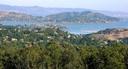
 View of the Golden Gate and San Francisco from the Marin Headlands.
 -
 Bridge and Bay waters.
 -
 Bridge traffic and SFs Presidio beyond.
 -
 Bridge tower and SF skyline.
 -
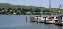
 Golden Gate tower and sailboats.
 -
 Another tower view.
 -
 Sunset colors over San Francisco.
 -
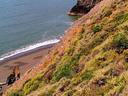
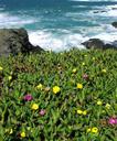
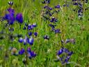
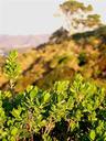
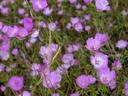
 Wildflowers along the Marin Headlands coast.
 -
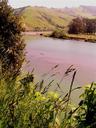
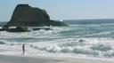
 Us celebrating our 2nd Wedding Anniversary on one of the many dark sand beaches along the Marin Headlands.
 -
 Ashe enjoying the waves at Headlands beach.
 -
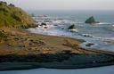
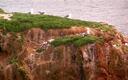
 View of SFs Baker Beach and Presidio coast from the Marin Headlands.
 -
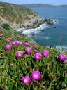
 Flowers in bloom along the Headlands cliffs.
 -
 Sunset from Headlands beach.
 -
 Fort Cronkhite and Rodeo Beach.
 -
 Rodeo Beach, minutes from San Francisco but feels hours away.
 -
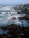
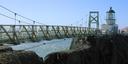 The Point Bonita Lighthouse guides ships from the Pacific into San Francisco Bay.
 -
 Lagoon at Rodeo Beach.
 -
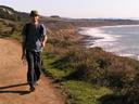
 Hikers enjoy the hilltop trails of the Marin Headlands and Golden Gate National Recreation Area.
 -
 Trail.
 -
 Views from the Marin Headlands hilltop trails.
 -
 Views from the hills.
 -
 View of the Farallon Islands.
 -
 The hilltops are bare, but lush forests fill the valleys below.
 -
 Ashe on the trail.
 -
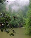 Deep in the valleys of the Marin hills are verdant forests, lush trails, and roaring creeks and cascades. We do some of our best hiking in these areas within easy reach from San Francisco.
 -
 Rushing waters, mossty rocks, and rustic bridges -- love it!
 -
 Green!
 -
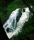
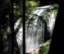
 Cataract Falls, a collection of cascades that flow endlessly through a deep gulch is one of our favorite spots!
 -
 Forest trail.
 -
 Lush and green.
 -
 Another of Cataract Canyons many waterfalls.
 -
 The final upper falls are a wild torrent on a rainy, winter day.
 -
 Gushing waters.
 -
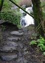
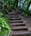 Trail steps -- follow these, leave the forest behind and hit the hilltops.
 -
 Green and misty hills above Cataract Canyon.
 -
 Hilltop pine.
 -
 Ashe and Maciej -- we made it to the top!
 -
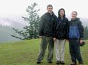 Craig, Jess, and Ashe on top of the hill.
 -
 Misty forest.
 -
 Cascade Canyon Creek just beyond the wonderful town of Fairfax.
 -
 Following the trail along the rushing creek.
 -
 Ferns along the creek.
 -
 More creek views.
 -
 Odd tree, cold to the touch.
 -
 Mossy branches and blue skies.
 -
 Final steps before reaching Cascade Falls.
 -
 Cascade Falls.
 -
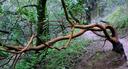
 Twisted, mossy branches.
 -
 Trail through the Baltimore Canyon just beyond the limits of the town of Larkspur.
 -
 Following the trail on our way to Dawn Falls.
 -
 Mossy stump.
 -
 Trailside creek.
 -
 Creek.
 -
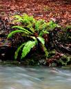 Fern along the creek.
 -
 Ashe with Nikki and Todd at Dawn Falls.
 -
 Dawn Falls.
 -
 Dawn Falls.
 -
 Rushing waters at Dawn Falls.
 -
 On the road up to Marins highest peak: Mt.Tamalpais.
 -
 San Francisco from the Mt.Tamalpais Road.
 -
 San Francisco from the road.
 -
 Marins hills with San Francisco in the distance.
 -
 The East Peak of Mt.Tamalpais with observatory.
 -
 Mt.Tamalpais, 2571 feet high.
 -
 View from Mt.Tamalpais.
 -
 Sunset from Mt.Tamalpais -- above the fog!
 -
 Maciej and Ashe enjoying the sunset.
 -
 The sun sets into the evening fog.
 -
 Evening view of southern Marin and San Francisco beyond from the top of Mt.Tamalpais.
 -
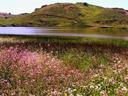
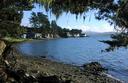
 Somewhere among the hills of Marin is the Three Lakes Region.
 -
 Walking along the Bon Tempe Lake trail.
 -
 Celebrating Ashes birthday at Bon Tempe Lake.
 -
 Lake views.
 -
 Old cabin.
 -
 Old cabin.
 -
 Deep valley river.
 -
 Sunrise over the Marin Headlands as we begin the Coast Trail.
 -
 Small lake along the Coast Trail.
 -
 Following the Coast Trail north into the southern end of Point Reyes National Seashore.
 -
 Coastal views.
 -
 Maciej on the Coast Trail.
 -
 Our Coast Trail destination was Alamere Falls. This is the upper cascade leading to the Falls.
 -
 Alamera Falls -- how often do you see a waterfall right on the beach?
 -
 Alamere Falls.
 -
 Views from Alamere Falls beach.
 -
 Ashe by Alamere Falls.
 -
 Maciej and Ashe on Alamere Falls beach.
 -
 Top of the Falls.
 -
 Ashe by the Falls.
 -
 Driving along Tomales Bay on our way to Point Reyes National Seashore.
 -
 Pond at Point Reyes.
 -
 Pond at Point Reyes.
 -
 Maciej on Point Reyes trail.
 -
 View to Stinson Beach.
 -
 Point Reyes Seashore.
 -
 Point Reyes Seashore.
 -
 Waves and sunset colors.
 -
 Sunset over the Point Reyes Lighthouse.
 -
 Ashe by forest creek.
 -
 Ashe on ladder along the Steep Ravine Trail near Marins Muir Woods.
 -
 Carson Falls.
 -
 Rolling hills.
 -
 Sunset skies.
 -
 Wildflowers along the Russian River.
 -
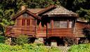
 Fantastic, rustic home along the Russian River.
 -
 Fantastic, rustic home along the Russian River.
 -
 Russian River shores.
 -
 Russian River.
 -
 Ashe along the Russian River.
 -
 Wildflowers along the road.
 -
 Bodega Bay -- one of our favorite destinations close to San Francisco and a great place for hiking.
 -
 The historic Bodega Church where Hitchcocks The Birds was filmed.
 -
 Flowering succulents along the Bodega Head Trail.
 -
 Ashe on Bodega Head beach.
 -
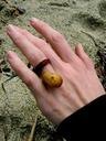 We got engaged on a beach at Bodega Head. Heres Ashe wearing her seaweed ring!
 -
 Bodega Head cliffs.
 -
 Bodega Head views.
 -
 Cliffs and surf.
 -
 Beautiful views at every turn along the Bodega Head Trail.
 -
 Ashe on the Bodega Head Trail.
 -
 Bodega Head beach.
 -
 Cliffs, flowers, and the mighty Pacific.
 -
 Flowering succulents.
 -
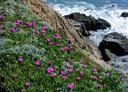 More flowering succulents.
 -
 Steep cliffs.
 -
 Fantastic views at the Bodega Head.
 -
 More rocky shores at Bodega Head.
 -
 Purple and yellow succulent blossoms.
 -
 Bodega cliffs.
 -
 More Bodega cliffs and flowers.
 -
 Brilliant red succulents!
 -
 Coastal flowers.
 -
 More flowering succulents.
 -
 Fields of wildflowers at Bodega Head.
 -
 More wildflowers.
 -
 Maciej on the cliff trail.
 -
 Rocky beach.
 -
 Coastal poppies.
 -
 Poppies.
 -
 Ashe climbing.
 -
 Cliffs.
 -
 Rocky shores.
 -
 Rocky cove.
 -
 Skunk.
 -
 Vulture.
 -
 Ashe gazing out to the ocean.
 -
 Ashe on Manchester State Beach.
 -
 Heron.
 -
 Cacti and flowers.
 -
 Cacti.
 -
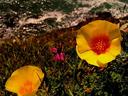
 California poppies, the State Flower.
 -
 Chamberlain Falls.
 -
 Chamberlain Falls.
 -
 Chamberlain Falls.
 -
 The hike-in campground at Chamberlain Falls -- the best campground weve seen in California.
 -
 Chamberlain Falls close up.
 -
 Beautiful cliffside flowers.
 -
 Cliffside flowers.
 -
 Cliffside flowers.
 -
 Highway 1 coastline north of San Francisco and approaching the Mendocino area.
 -
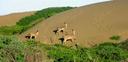 Deer at Manchester State Beach.
 -
 Dunes at Manchester State Beach.
 -
 Fern Canyon Trail.
 -
 Fern Canyon Trail.
 -
 Fern Canyon Trail.
 -
 Our footprints at Manchester State Beach.
 -
 Fort Ross.
 -
 Fort Ross.
 -
 Fort Ross.
 -
 Canon at Fort Ross.
 -
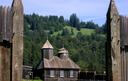 Fort Ross.
 -
 Fort Ross.
 -
 Fort Ross workroom.
 -
 Maciej at Point Arena Lighthouse.
 -
 Maciej at Russian Gulch Falls.
 -
 Manchester State Beach dunes.
 -
 Mendocino coast.
 -
 Mendocino coast.
 -
 Mendocino coast.
 -
 Mushroom.
 -
 Point Arena Lighthouse.
 -
 Point Arena Lighthouse.
 -
 Point Cabrillo Lighthouse.
 -
 Point Cabrillo Lighthouse.
 -
 Russian Gulch Falls.
 -
 Russian Gulch Falls.
 -
 Mendocino coast.
 -
 Salt Point State Park.
 -
 Fabulous coastline.
 -
 Turbulent waters.
 -
 Winding Highway 1.
 -
 Yellow poppy.
 -
 Sunset over the town of Elk.
 -
 Views from Mt.St.Helena, north of San Francisco.
 -
 More Mt.St.Helena views.
 -
 Another view from our Mt.St.Helena hike.
 -
 Wildflowers.
 -
 Craig, Ashe and Jess hiking the hills over the East Bay.
 -
 On the southernmost end of San Francisco is another wonderful hiking spot: Fort Funston.
 -
 Ashe on the Fort Funston trail.
 -
 Fort Funston cliffs looking north to Ocean Beach.
 -
 Fort Funston cliffs.
 -
 Sandy, cliff-top trail.
 -
 Ashe on Fort Funston trail.
 -
 Fort Funston is a favorite with hang-gliders.
 -
 Ready to jump.
 -
 Love those cliff-top sand dunes.
 -
 Just south of San Francisco, the city of Pacifica is aptly named with the city built right up to beaches and coastline like this one.
 -
 Pacifica cliffs and beach.
 -
 Pacifica beach at Rockaway Cove.
 -
 Pacifica coastline.
 -
 Ashe at Half Moon Bay beach.
 -
 Pacifica cliffs.
 -
 Half Moon Bay beach, cliffs, and blue skies.
 -
 Clouds over Half Moon Bay beach.
 -
 At the southern end of Pacifica lies Pedro Point with a great trail bringing you to the top of the point and beyond to a secluded stretch of Pacific coast.
 -
 Pedro Point trail.
 -
 Ging, Jess, Craig and Ashe on the Pedro Point trail.
 -
 Views from up high over Pacifica.
 -
 Views from Pedro Point.
 -
 Plants on the trail.
 -
 Pacific views from Pedro Point trail.
 -
 Sunset clouds.
 -
 Surrounded by hills.
 -
 Ocean trail.
 -
 Wildflowers along the trail.
 -
 Slightly inland from Pacifica is the Montara Mountain ridge. Ashe makes her way up the trail to the top of Montara Mountain.
 -
 Montara trail views.
 -
 View of Pacifica from the Montara Mountain trail.
 -
 Montara trail views.
 -
 Trail salamander.
 -
 Maciej at Mt.Montara overlook.
 -
 Views of Pacifica and SF from the top of Mt.Montara.
 -
 The fog begins to roll in.
 -
 Southern ridge views from Mt.Montara.
 -
 Views from Mt.Montara trail.
 -
 Further south from San Francisco is the town of Half Moon Bay with its own fantastic beach.
 -
 Half Moon Bay Beach and cliffs.
 -
 Half Moon Bay beach cliffs.
 -
 Half Moon Bay beach.
 -
 Half Moon Bay beach and creek.
 -
 Half Moon Bay home.
 -
 Half Moon Bay home.
 -
 Half Moon Bay coast at sunset.
 -
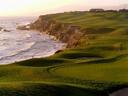 Half Moon Bay coastline and golf course at the Ritz Carlton Hotel.
 -
 Sunset at Half Moon Bay beach.
 -
 Driving south along Highway 1 from San Francisco is great anytime of year, but best in the Spring.
 -
 Fields of wildflowers.
 -
 Beach off the highway.
 -
 Forest creek.
 -
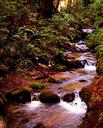 Lush forest and creek just inland off of the coastal highway.
 -
 Creek.
 -
 Small forest waterfall.
 -
 Trail scenery.
 -
 One of our favorites, Hole-in-the-Wall Beach near Davenport and Santa Cruz is reached only by passing through this opening in an oceanside cliff.
 -
 Naked cowboy at Hole-in-the-Wall Beach.
 -
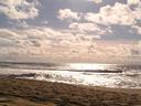
 Beach waves.
 -
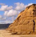
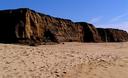
 Yellow cliffs.
 -
 Great views at the beach.
 -
 Ashe at Hole-in-the-Wall Beach.
 -
 Seaweed on the beach.
 -
 Our shadows!
 -
 Pigeon Point Lighthouse sunset.
 -
 Not far inland from the coast, Pinnacles National Monument.
 -
 Views from the Pinnacles trail.
 -
 Wildflowers.
 -
 Flowers and rock spires.
 -
 Rock pinnacles.
 -
 A tight pass through the Pinnacles.
 -
 Delicate wildflowers.
 -
 One of Californias most popular State Parks -- Ano Nuevo offers visitors a look at the mating and birthing rituals of elephant seals.
 -
 Beach at Ano Nuevo State Park.
 -
 Grasses and shrubbery at Ano Nuevo.
 -
 Ashe at Ano Nuevo beach.
 -
 Elephant seal on the beach.
 -
 Elephant seal on the beach.
 -
 Elephant seals.
 -
 Lots of elephant seals.
 -
 Further inland from the ocean, the Sunol Regional Wilderness protects a large expanse of rolling hills and ranch land.
 -
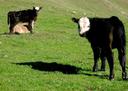 Cattle.
 -
 Grazing cattle.
 -
 Mother and calf.
 -
 Large oak.
 -
 Cow family.
 -
 Ranch.
 -
 Tree and shadow.
 -
 Hiking trail.
 -
 Maciej at Cave Rocks.
 -
 This way for Little Yosemite.
 -
 Oaks.
Oaks. -
 Oaks and shadows.
 -
 When we have time, we often may the longer drive south to Big Sur -- the best of Californias coast. Heres the view from the Headland Trail at Andrew Molera State Park.
 -
 Another view from the headlands at Andrew Molera.
 -
 Ashe and Maciej on the beach at Asilomar.
 -
 Ashe at Asilomar, one of our favorite stops along the coast while making our way further south.
 -
 Cliffs and ocean -- a Big Sur specialty.
 -
 Big Sur ocean views.
 -
 Views north along the Big Sur coast.
 -
 Bird rock at Point Lobos State Park.
 -
 Flowers.
 -
 Boardwalk at Asilomar.
 -
 Cacti at Garrapata State Park.
 -
 Coastal flowers.
 -
 Deer.
Deer. -
 Fog rolling in over hillside Naciemento Road.
 -
 Rolling fog.
 -
 Foggy hills.
 -
 Foggy road.
 -
 Foggy valley.
 -
 Mysterious...
 -
 Old port building at San Simeon port, ocean access point for Hearst Castle.
 -
 Trees with lichen at Point Lobos State Park.
 -
 Creek at our favorite of Big Surs many State Parks: Limekiln State Park.
 -
 Limekiln Falls.
 -
 Trail in Limekiln Park.
 -
 Scary!
 -
 Maciej and Ashe at Asilomar.
 -
 Maciej and Ashe at Asilomar.
 -
 Big Surs famous McWay Falls.
 -
 McWay Falls.
 -
 McWay Falls (again!).
 -
 Big Sur hills at Naciemento Road.
 -
 Big Sur coast.
 -
 Big Sur coast.
 -
 Big Sur coast.
 -
 Big Sur coast with sunset colors.
 -
 Picnicing with Jacek at Andrew Molera.
 -
 Branches and rocks at Point Lobos.
 -
 Flowers.
 -
 Flowers along the coast.
 -
 Rock off Andrew Molera headlands.
 -
 Rocks and surf.
 -
 Ocean views at Asilomar.
 -
 Salmon Creek Falls.
 -
 Beach and pier at San Simeon.
 -
 Snake!
 -
 Rocky shores.
 -
 Waves.
 -
 Flowers.
 -
 Flowers and fence.
 -
 Sunset from Naciemento Road.
 -
 Sunset from Naciemento Road.
 -
 Sunset skies.
 -
 Sunset from Naciemento Road.
 -
 Sunset from Naciemento Road.
 -
 Ashe with Nikki on King Mountain Loop trail.
 -
 Ashe Statia and James taking a break on Marin Headlands trail.
 -
 Joyce Ashe and Leah at Golden Gate vista point.
 -
 Leah Ashe Joyce and Maciej acrobatics.
 -
 Maciej and Todd at Cataract Falls.
Move your mouse over a pin on the map and you will see some information here!